Charting the Future of Aquatic Ecosystems
Safeguarding aquatic ecosystems with daily satellite intelligence and water quality forecasting.
Field Research
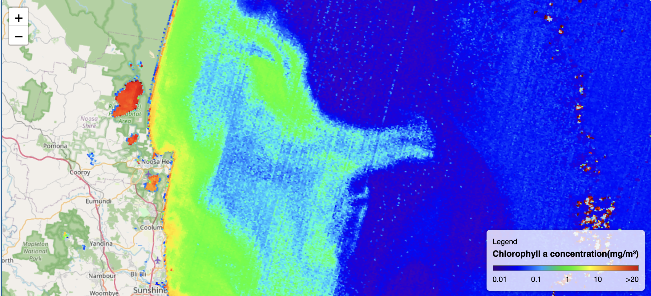
Monitoring active research locations with real-time satellite synchronization.
The map showcases chlorophyll-a concentration in water bodies which is a key indicator that shows the amount of algae in the water, used to track water quality and spot potential algae blooms.
Active Research Sites
Our Core Methodologies
Leveraging state-of-the-art telemetry and hydrobiological analysis to provide authoritative insights.
Algal Bloom Risk Mitigation
Excess nutrients lead to rapid algae growth. Our reports help you detect these blooms early before they deplete oxygen, harm aquatic life, or produce toxins dangerous to humans and animals.
Chlorophyll-A & Phycocyanin Tracking
Chlorophyll-A serves as a key indicator of overall algal biomass, while Phycocyanin is a pigment specific to cyanobacteria. Monitoring both metrics helps detect nutrient pollution, assess ecosystem health, and identify potential harmful algal bloom risks.
Water Quality Analysis
Comprehensive chemical and physical screening using proprietary real-time data for industrial and conservation zones. Aquatic Insights and hydrobiology reports
Our Clients & Partners
Collaborating with organizations committed to protecting aquatic ecosystems and advancing sustainable water management.
Pirin National Park
It is one of the three national parks in the country, the others being Rila National Park and Central Balkan National Park. The park was established in 1962 and its territory was expanded several times since then. Pirin National Park was declared a UNESCO World Heritage Site in 1983.
WaterWarden partnered with "Pirin National Park" with researching and monitoring glacial lakes in the park.
Bulgarian Biodiversity Foundation
BBF has been working to conserve biodiversity in Bulgaria and neighboring countries, supports the participation of citizens and local communities. WaterWarden has partnered with reports about the effects of mining industry on aquatic ecosystems
Visit websiteBlack Sea NGO Network
Black Sea NGO Network (BSNN) came into existence in 1998 as a result of the development of the NGO community in the countries surrounding the Black Sea. Its predecessor was the International Black Sea NGO Forum. The first regional meeting of the network was held in Varna in September 1998. We have partnered with BSNN on multiple occasions regarding Black Sea conservations events and lectures where we had the opportunity to present us and our mission. Check out our related blog: Varna Bay and its water quality
Visit websiteEast Aegean River Basin Directorate
The East Aegean River Basin Directorate is a regional water management authority in Bulgaria with its headquarters located in Plovdiv. It operates under the Ministry of Environment and Water to manage river catchments, protect water resources, and implement environmental standards. They were crucial partners in validating our data and field testing our platform.
Visit websiteUniversity of Economics – Varna
The University of Economics – Varna is a public university located in Varna, Bulgaria, focused on studies in the field of economics. The university has an accreditation issued by the National Evaluation and Accreditation Agency.
Visit websiteLatest Insights
WaterWarden Reaches the Top 10 at Startup World Cup 2026 Varna
We're excited to share some incredible news—WaterWarden was selected as one of the Top 10 startups in Bulgaria to compete at the Startup World Cup 2026 Varna.
Water Warden Wins First Place & Best Innovation at Blue Heritage Innovators 2026
Water Warden took home First Place overall and the Best Innovation Award at the Blue Heritage Innovators 2026 bootcamp! Read how our zero-hardware satellite intelligence platform provides proactive early warnings for toxic algal blooms , and how municipalities, coastal resorts, and regional water utilities can partner with us to ensure water safety for the upcoming summer season
The case of a Varna Bay and its water quality
Large coastal cities frequently face challenges related to water quality, and Varna is no exception. Using the WaterWarden platform, we were able to detect clear signs of water contamination, including elevated chlorophyll and suspended matter levels. These indicators strongly suggest illegal sewage discharge into the sea—an issue made highly visible through the satellite-derived data and visualization tools provided by the platform.
Why does Algae and Chlorophyll matters?
Many natural and anthropogenic factors can drive the rapid development of Algae in the water body which can lead to many different issues in the ecosystems. Lets discover a quick overview of the Algae and Chlorophyll.
Initiate Your Technical Inquiry
Our multi-disciplinary knowledge is ready to assist with complex environmental challenges and data verification projects.
Email Us
info@water-warden.com